[vc_row full_width=”stretch_row_content_no_spaces” content_placement=”top” css=”.vc_custom_1522863082502{margin-top: 0px !important;margin-right: 0px !important;margin-bottom: 0px !important;margin-left: 0px !important;border-top-width: 0px !important;border-right-width: 0px !important;border-bottom-width: 0px !important;border-left-width: 0px !important;padding-top: 0px !important;padding-right: 0px !important;padding-bottom: 0px !important;padding-left: 0px !important;background-color: rgba(2,2,2,0.01) !important;*background-color: rgb(2,2,2) !important;}”][vc_column][vc_column_text][rev_slider_vc alias=”big-mountain-post” el_class=”topslider”][/vc_column_text][/vc_column][/vc_row][vc_row full_width=”stretch_row_content” content_placement=”top” css=”.vc_custom_1490815124103{margin-bottom: 0px !important;border-top-width: 5px !important;border-bottom-width: 4px !important;padding-top: 4px !important;padding-bottom: 4px !important;background-color: #ffffff !important;border-top-color: #777777 !important;border-top-style: outset !important;border-bottom-color: #777777 !important;border-bottom-style: outset !important;}”][vc_column width=”1/4″ offset=”vc_col-lg-offset-0 vc_col-md-offset-0 vc_col-md-3 vc_col-xs-12″ css=”.vc_custom_1522863410691{margin-bottom: 0px !important;border-bottom-width: 0px !important;padding-bottom: 0px !important;}”][vc_column_text el_class=”smalltext”]Published: [date] by PICSPORADIC [/vc_column_text][/vc_column][vc_column width=”5/12″ offset=”vc_hidden-md vc_hidden-sm vc_col-xs-2 vc_hidden-xs”][vc_column_text el_class=”smalltext”]
All of the photos on this page can be purchased for download or print ? Visit store
[/vc_column_text][/vc_column][vc_column width=”1/12″ offset=”vc_col-xs-3″ css=”.vc_custom_1522975589935{margin-bottom: 0px !important;border-bottom-width: 0px !important;padding-bottom: 0px !important;}”][vc_facebook type=”button_count” css=”.vc_custom_1490816047681{margin-top: 4px !important;}”][/vc_column][vc_column width=”1/12″ offset=”vc_col-xs-3″ css=”.vc_custom_1522975656647{margin-bottom: 0px !important;border-bottom-width: 0px !important;padding-bottom: 0px !important;padding-left: 20px !important;}”][vc_googleplus annotation=”none” css=”.vc_custom_1490816144508{margin-top: 2px !important;}”][/vc_column][vc_column width=”1/6″ offset=”vc_col-xs-6″ css=”.vc_custom_1522975582023{margin-top: 0px !important;margin-bottom: 0px !important;border-top-width: 0px !important;border-bottom-width: 0px !important;padding-top: 4px !important;padding-bottom: 0px !important;}”][vc_column_text el_class=”smalltext”]
[views] [comments]
[/vc_column_text][/vc_column][/vc_row][vc_row full_width=”stretch_row_content_no_spaces” equal_height=”yes” content_placement=”bottom” css=”.vc_custom_1522815957968{margin-top: 0px !important;margin-bottom: 0px !important;border-top-width: 0px !important;border-bottom-width: 0px !important;background-color: #383838 !important;}”][vc_column offset=”vc_col-lg-offset-2 vc_col-lg-5 vc_col-md-offset-1 vc_col-md-7 vc_col-sm-offset-0 vc_col-xs-12″ css=”.vc_custom_1493253569498{padding-top: 20px !important;padding-right: 20px !important;padding-bottom: 20px !important;padding-left: 20px !important;background-color: #232323 !important;}”][vc_custom_heading text=”A visit to Guatemala” font_container=”tag:h1|font_size:30px|text_align:left|color:%23ffffff|line_height:30px” google_fonts=”font_family:Alfa%20Slab%20One%3Aregular|font_style:400%20regular%3A400%3Anormal” el_class=”white”][vc_custom_heading text=”Volcanoes, valleys, and Mayan culture with Big Mountain Bike Adventures” font_container=”tag:h2|font_size:20|text_align:left|color:%23e8e8e8|line_height:20px” google_fonts=”font_family:Advent%20Pro%3A100%2C200%2C300%2Cregular%2C500%2C600%2C700|font_style:500%20bold%20regular%3A500%3Anormal” el_class=”white”][vc_column_text el_class=”light”]Back at it again! For this trip I had the opportunity to guide and photograph a new multi-day travel itinerary for Whistler based Big Mountain Bike Adventures. While juggling roles I got to snap some great pictures and introduce my favorite country to a group of pretty rad female riders. Vámonos.
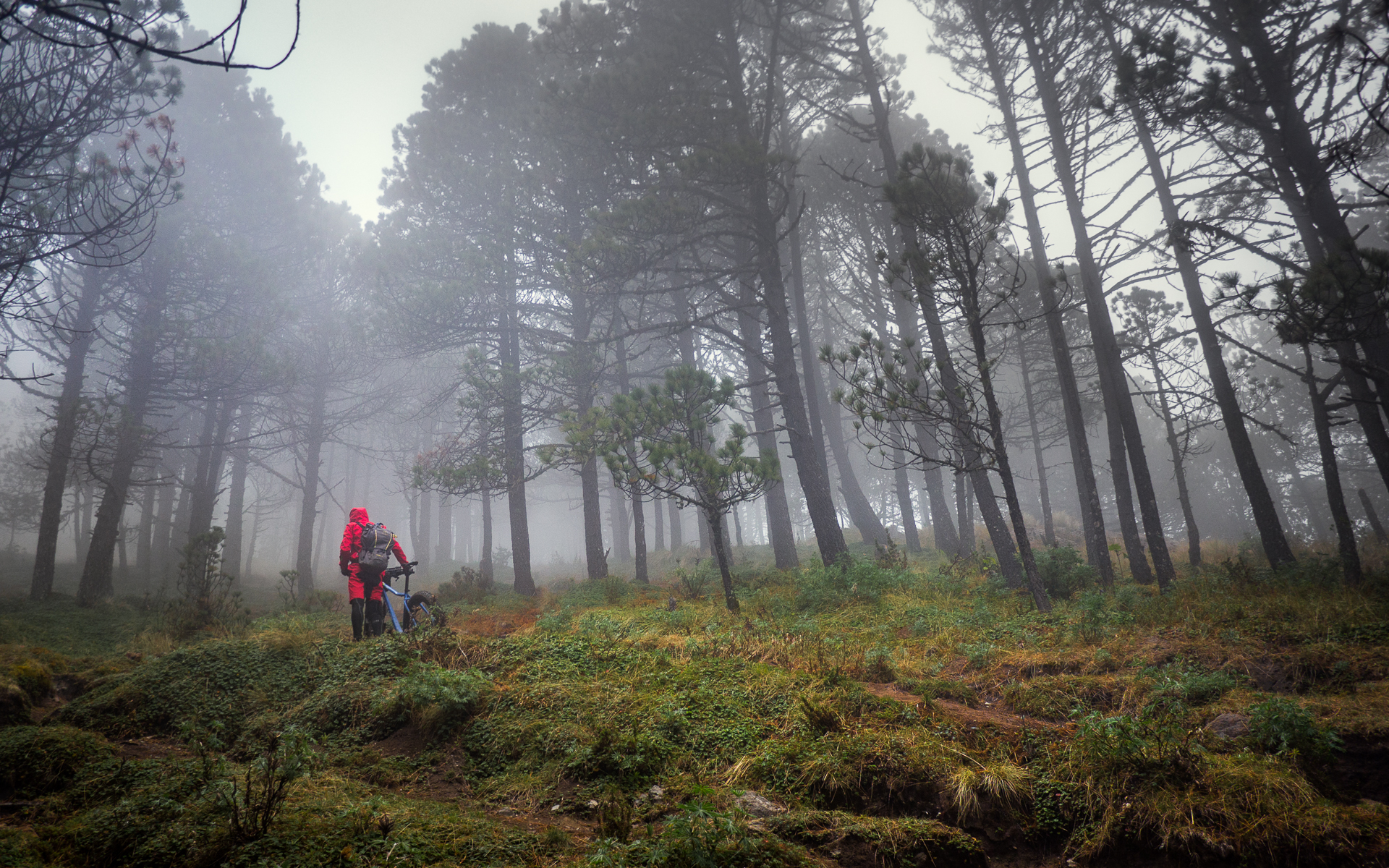
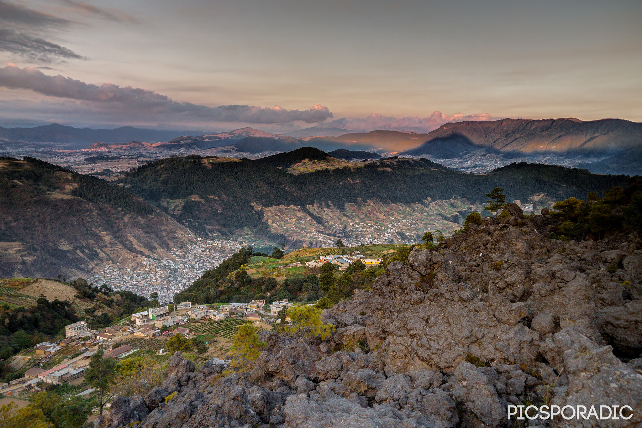
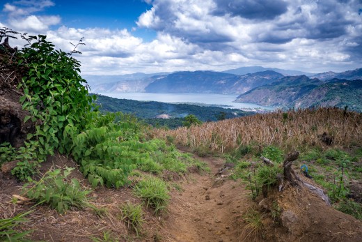
This 6-day mountain bike mega itinerary put together in conjunction with Old Town Outfitters connected the highlands in a grand traverse which included the 3,976m summit of Volcán de Acatenango – the forests of Tecpán and beautiful Lake Atitlán. Ambitious in scope, the trip was sure to impress – but where the ladies up for it?[/vc_column_text][vc_custom_heading text=”The Land of Eternal Spring” font_container=”tag:h2|font_size:20|text_align:left|color:%23e8e8e8|line_height:20px” google_fonts=”font_family:Advent%20Pro%3A100%2C200%2C300%2Cregular%2C500%2C600%2C700|font_style:500%20bold%20regular%3A500%3Anormal” el_class=”white”][vc_single_image image=”13478″ img_size=”full” style=”vc_box_border” onclick=”custom_link” img_link_target=”_blank” css_animation=”none” css=”.vc_custom_1551668851668{margin-top: 20px !important;}” link=”https://www.picsporadic.com/items/guatemala-aerial-180325-001-dji/”][vc_column_text el_class=”light”]The climate in this part of Guatemala is characterized by cool, clear weather with temps from 4-25°C – perfect for biking. Flowers bloom year-round here and sunrise and sunset give predictable 12 hour days.
Coming from the heart of the Canadian winter a trip to Antigua can be a refreshing change of climate – however, many of the riders had not been on the bike in months. No fear! We spent the first few days warming up and planned to maximize our downhills using creative shuttling enduro-style.[/vc_column_text][vc_single_image image=”13710″ img_size=”full” style=”vc_box_border” onclick=”custom_link” img_link_target=”_blank” css_animation=”none” css=”.vc_custom_1551668789837{margin-top: 20px !important;}” link=”https://www.picsporadic.com/items/guatemala-aerial-180325-001-dji/”][vc_custom_heading text=”A wealth of Trails to Explore” font_container=”tag:h2|font_size:20|text_align:left|color:%23e8e8e8|line_height:20px” google_fonts=”font_family:Advent%20Pro%3A100%2C200%2C300%2Cregular%2C500%2C600%2C700|font_style:500%20bold%20regular%3A500%3Anormal” el_class=”white”][vc_column_text el_class=”light”]Antigua is situated in a valley of valleys with elevations ranging from 1,500-2,700m above sea level. Agriculturally rich, most crops here are planted and harvested by hand. It’s easy for the mountain biker’s mind to wander admiring the patchwork of fields that dot the landscape, most of which are interconnected by ancient footpaths and horse trails. Just point and go![/vc_column_text][vc_single_image image=”14831″ img_size=”full” style=”vc_box_border” onclick=”custom_link” img_link_target=”_blank” css_animation=”none” css=”.vc_custom_1522888992020{margin-top: 20px !important;}” link=”https://www.picsporadic.com/items/guatemala-aerial-180325-001-dji/”][/vc_column][vc_column css=”.vc_custom_1522879880914{border-bottom-width: 40px !important;background-color: #232323 !important;}” offset=”vc_col-lg-3 vc_col-md-3 vc_col-xs-12″][vc_row_inner equal_height=”yes” css=”.vc_custom_1522872929891{margin-top: 5px !important;margin-right: 20px !important;margin-bottom: 5px !important;margin-left: 5px !important;border-top-width: 2px !important;border-right-width: 2px !important;border-bottom-width: 2px !important;border-left-width: 2px !important;background-color: rgba(0,0,0,0.01) !important;*background-color: rgb(0,0,0) !important;border-left-color: #606060 !important;border-left-style: none !important;border-right-color: #606060 !important;border-right-style: none !important;border-top-color: #606060 !important;border-top-style: none !important;border-bottom-color: #606060 !important;border-bottom-style: none !important;border-radius: 5px !important;}”][vc_column_inner width=”5/12″ offset=”vc_col-lg-offset-0 vc_col-lg-8 vc_col-md-offset-0 vc_col-md-8 vc_col-sm-offset-2 vc_col-xs-8″ css=”.vc_custom_1522960856869{margin-top: 5px !important;border-left-width: 0px !important;}”][vc_custom_heading text=”Brendan James” font_container=”tag:h2|font_size:20|text_align:left|color:%23c9c9c9|line_height:20px” google_fonts=”font_family:Advent%20Pro%3A100%2C200%2C300%2Cregular%2C500%2C600%2C700|font_style:500%20bold%20regular%3A500%3Anormal” el_class=”white”][vc_column_text]Adventure photographer, athlete and bike guide based in Antigua, Guatemala. Full bio[/vc_column_text][/vc_column_inner][vc_column_inner width=”1/6″ offset=”vc_col-lg-4 vc_col-md-4 vc_col-xs-4″ css=”.vc_custom_1522873767410{margin-top: 5px !important;margin-bottom: 5px !important;}”][vc_single_image image=”4281″ img_size=”full” style=”vc_box_circle_2″ onclick=”custom_link” img_link_target=”_blank” link=”https://www.picsporadic.com/bio”][/vc_column_inner][/vc_row_inner][vc_custom_heading text=”Thank you to:” font_container=”tag:h1|font_size:18|text_align:center|color:%23dddddd|line_height:18px” google_fonts=”font_family:Exo%3A100%2C100italic%2C200%2C200italic%2C300%2C300italic%2Cregular%2Citalic%2C500%2C500italic%2C600%2C600italic%2C700%2C700italic%2C800%2C800italic%2C900%2C900italic|font_style:500%20bold%20regular%3A500%3Anormal” el_class=”white” css=”.vc_custom_1522818020611{margin-top: 35px !important;margin-right: 10px !important;}”][vc_row_inner equal_height=”yes” css=”.vc_custom_1522873952061{margin-right: 5px !important;margin-bottom: 10px !important;margin-left: 10px !important;border-top-width: 2px !important;border-right-width: 2px !important;border-bottom-width: 2px !important;border-left-width: 2px !important;padding-right: 5px !important;padding-left: 5px !important;background-color: rgba(0,0,0,0.01) !important;*background-color: rgb(0,0,0) !important;border-left-color: #606060 !important;border-left-style: solid !important;border-right-color: #606060 !important;border-right-style: solid !important;border-top-color: #606060 !important;border-top-style: solid !important;border-bottom-color: #606060 !important;border-bottom-style: solid !important;border-radius: 5px !important;}”][vc_column_inner width=”1/12″ offset=”vc_col-lg-3 vc_col-md-4 vc_col-xs-3″ css=”.vc_custom_1522816214639{margin-top: 20px !important;margin-left: 0px !important;border-left-width: 0px !important;padding-left: 0px !important;}”][vc_single_image image=”14839″ img_size=”full” style=”vc_box_circle_2″ onclick=”custom_link” img_link_target=”_blank” css=”.vc_custom_1522898016497{margin-top: 5px !important;margin-right: 5px !important;margin-bottom: 5px !important;margin-left: 5px !important;}” link=”http://www.ridebig.com”][/vc_column_inner][vc_column_inner width=”5/12″ css=”.vc_custom_1522816887069{margin-top: 20px !important;padding-left: 7px !important;}” offset=”vc_col-lg-9 vc_col-xs-9″][vc_custom_heading text=”Big Mountain Bike Adventures” font_container=”tag:h2|font_size:18|text_align:left|color:%23c9c9c9|line_height:18px” google_fonts=”font_family:Advent%20Pro%3A100%2C200%2C300%2Cregular%2C500%2C600%2C700|font_style:500%20bold%20regular%3A500%3Anormal” el_class=”white”][vc_column_text]The leader in guided mountain bike adventures to global destinations. www.ridebig.com
[/vc_column_text][/vc_column_inner][vc_column_inner width=”1/12″ offset=”vc_col-lg-3 vc_col-md-4 vc_col-xs-3″ css=”.vc_custom_1522816226310{margin-top: 20px !important;margin-left: 0px !important;border-left-width: 0px !important;padding-left: 0px !important;}”][vc_single_image image=”14840″ img_size=”full” style=”vc_box_circle_2″ onclick=”custom_link” img_link_target=”_blank” css=”.vc_custom_1522897999669{margin-top: 5px !important;margin-right: 5px !important;margin-bottom: 5px !important;margin-left: 5px !important;}” link=”http://www.adventureguatemala.com”][/vc_column_inner][vc_column_inner width=”5/12″ css=”.vc_custom_1522817639476{margin-top: 20px !important;margin-bottom: 20px !important;padding-left: 7px !important;}” offset=”vc_col-lg-9 vc_col-md-8 vc_col-xs-9″][vc_custom_heading text=”Old Town Outfitters” font_container=”tag:h2|font_size:18|text_align:left|color:%23c9c9c9|line_height:18px” google_fonts=”font_family:Advent%20Pro%3A100%2C200%2C300%2Cregular%2C500%2C600%2C700|font_style:500%20bold%20regular%3A500%3Anormal” el_class=”white”][vc_column_text]Pioneers of Guatemala’s finest mountain bike rides and backcountry tours. adventureguatemala.com
[/vc_column_text][/vc_column_inner][/vc_row_inner][vc_custom_heading text=”Gallery” font_container=”tag:h1|font_size:30px|text_align:right|color:%23ffffff|line_height:40px” google_fonts=”font_family:Exo%3A100%2C100italic%2C200%2C200italic%2C300%2C300italic%2Cregular%2Citalic%2C500%2C500italic%2C600%2C600italic%2C700%2C700italic%2C800%2C800italic%2C900%2C900italic|font_style:500%20bold%20regular%3A500%3Anormal” el_class=”white” css=”.vc_custom_1522872747287{margin-top: 40px !important;margin-right: 20px !important;margin-left: 20px !important;}”][jig_vc][justified_image_grid row_height=150 height_deviation=100 caption=off margin=5px orderby=rand limit=30 max_rows=7 last_row=hide recent_posts=yes recents_filter_tax=collection recents_filter_term=big-mountain-2017 recents_post_type=sell_media_item][/jig_vc][vc_column_text]
View full gallery
[/vc_column_text][vc_custom_heading text=”Recent Posts” font_container=”tag:h1|font_size:20px|text_align:right|color:%23878787|line_height:20px” google_fonts=”font_family:Exo%3A100%2C100italic%2C200%2C200italic%2C300%2C300italic%2Cregular%2Citalic%2C500%2C500italic%2C600%2C600italic%2C700%2C700italic%2C800%2C800italic%2C900%2C900italic|font_style:600%20bold%20regular%3A600%3Anormal” el_class=”white” css=”.vc_custom_1522872760595{margin-top: 35px !important;margin-right: 20px !important;margin-left: 20px !important;}”][jig_vc][justified_image_grid row_height=100 caption=fade caption_opacity=1 caption_bg_color=109,76,52,0.8 caption_text_color=white caption_title_size=12px v_center_captions=yes specialfx=everything specialfx_type=desaturate orderby=menu_order max_rows=2 recent_posts=yes recents_description=nicetime][/jig_vc][vc_empty_space height=”20px”][/vc_column][/vc_row][vc_row full_width=”stretch_row_content_no_spaces” content_placement=”top” css=”.vc_custom_1493229127906{margin-top: 0px !important;margin-bottom: 0px !important;border-top-width: 0px !important;border-bottom-width: 0px !important;background-color: #383838 !important;}”][vc_column css=”.vc_custom_1522873382707{margin-top: 60px !important;border-top-width: 0px !important;padding-top: 0px !important;background-color: #ffffff !important;}” offset=”vc_col-lg-offset-2 vc_col-lg-8 vc_col-md-offset-1 vc_col-md-10 vc_col-xs-12″][vc_single_image image=”13552″ img_size=”full”][vc_column_text css=”.vc_custom_1522902125972{padding-left: 10px !important;}”]
Crossing the legendary “puente del trunco” – El Zur bike park. | ?
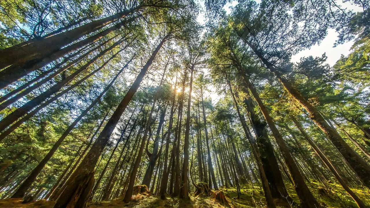
[/vc_column_text][/vc_column][/vc_row][vc_row full_width=”stretch_row_content_no_spaces” content_placement=”top” css=”.vc_custom_1493092617192{margin-top: 0px !important;margin-bottom: 0px !important;border-top-width: 0px !important;border-bottom-width: 0px !important;background-color: #383838 !important;}”][vc_column video_bg=”yes” css=”.vc_custom_1551669363319{margin-top: 0px !important;border-top-width: 0px !important;padding-top: 0px !important;background-color: #232323 !important;}” offset=”vc_col-lg-offset-2 vc_col-lg-8 vc_col-md-offset-1 vc_col-md-10 vc_col-xs-12 vc_hidden-xs”][vc_video link=”https://youtu.be/EA7vWtwl2ak”][vc_column_text css=”.vc_custom_1521333375887{padding-left: 20px !important;}”]Shutting in the dusty jungle – El Zur Bike Park – Esquintla, Guatemala[/vc_column_text][/vc_column][/vc_row][vc_row full_width=”stretch_row_content_no_spaces” equal_height=”yes” content_placement=”top” css=”.vc_custom_1493310876032{margin-top: 0px !important;margin-bottom: 0px !important;border-top-width: 0px !important;border-bottom-width: 0px !important;background-color: #383838 !important;}”][vc_column width=”5/12″ offset=”vc_col-lg-offset-2 vc_col-lg-4 vc_col-md-offset-1 vc_col-md-5 vc_col-sm-offset-0 vc_col-xs-12″ css=”.vc_custom_1493313751677{padding-top: 20px !important;padding-right: 20px !important;padding-bottom: 20px !important;padding-left: 20px !important;background-color: #f9f9f9 !important;}”][vc_custom_heading text=”El Zur” font_container=”tag:h1|font_size:30px|text_align:left|color:%23606060|line_height:30px” google_fonts=”font_family:Alfa%20Slab%20One%3Aregular|font_style:400%20regular%3A400%3Anormal” el_class=”white”][vc_custom_heading text=”A Private Jungle Bike Park” font_container=”tag:h2|font_size:20|text_align:left|color:%233f3f3f|line_height:20px” google_fonts=”font_family:Advent%20Pro%3A100%2C200%2C300%2Cregular%2C500%2C600%2C700|font_style:500%20bold%20regular%3A500%3Anormal” el_class=”white”][vc_column_text]Situated on the southern side of Volcán de Agua (3,760 m), El Zur has a unique micro-climate relying on the coastal rain and fog from the Pacific a mere 50km away. The area is a unique place to see old growth forest, enormous trees, and a variety of wildlife.
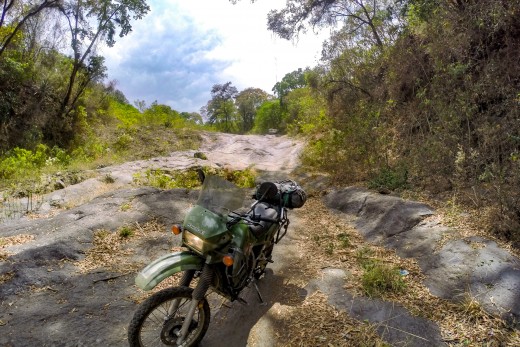
Old Town Outfitters operates a 20km trail that snakes its way down the volcano crossing dry volcanic lava flows, switchbacking through steep ravines and floating through the forest.
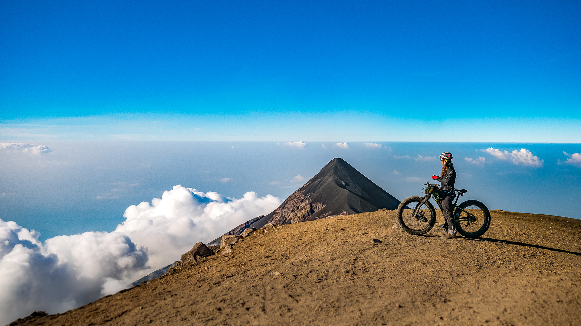
Our day began with an hour-long drive by car from Antigua followed by a white-knuckle shuttle ride up the volcano on 4×4 trails. At the top was an impressive clearing with views of the neighboring Fuego and Acatenango volcanoes.[/vc_column_text][/vc_column][vc_column width=”7/12″ css=”.vc_custom_1522889214749{padding-top: 5px !important;padding-right: 5px !important;background-color: #f9f9f9 !important;}” offset=”vc_col-lg-4 vc_col-md-5″][vc_single_image image=”13515″ img_size=”large” onclick=”custom_link” img_link_target=”_blank” link=”https://www.picsporadic.com/items/BIGMTN-180218-118-G85″ css=”.vc_custom_1522902674114{padding-left: 10px !important;}”][vc_column_text css_animation=”none”]
The crew lined up and ready to go at the top of the first run.
[/vc_column_text][jig_vc][/jig_vc][/vc_column][vc_column offset=”vc_col-lg-offset-2 vc_col-lg-8 vc_col-md-offset-1 vc_col-md-10 vc_col-xs-12″ css=”.vc_custom_1522806992305{background-color: #f9f9f9 !important;}”][jig_vc][justified_image_grid thumbs_spacing=10 row_height=200 height_deviation=100 title_field=caption caption=off mobile_caption=off caption_opacity=1 caption_bg_color=rgba(0,0,0,0.0) caption_text_color=grey caption_align=center lightbox=attachment margin=3px orderby=title_asc last_row=hide aspect_ratio=1/1 disable_cropping=no rml_id=174 rml_lightbox_groups=no rml_breadcrumb=no][/jig_vc][vc_column_text css=”.vc_custom_1521471400649{padding-left: 20px !important;}”]Riding in El Zur is unlike any place in North America – with enormous trees vines and patches of wild bannana trees.
[/vc_column_text][/vc_column][/vc_row][vc_row full_width=”stretch_row_content_no_spaces” content_placement=”top” css=”.vc_custom_1493092617192{margin-top: 0px !important;margin-bottom: 0px !important;border-top-width: 0px !important;border-bottom-width: 0px !important;background-color: #383838 !important;}”][vc_column video_bg=”yes” video_bg_url=”https://www.youtube.com/watch?v=upNHngzJheI” video_bg_parallax=”content-moving” css=”.vc_custom_1553129757587{margin-top: 0px !important;border-top-width: 0px !important;padding-top: 0px !important;background-color: #232323 !important;}” offset=”vc_col-lg-offset-2 vc_col-lg-8 vc_col-md-offset-1 vc_col-md-10 vc_col-xs-12 vc_hidden-xs”][vc_empty_space height=”80vh”][vc_column_text css=”.vc_custom_1521335091532{padding-left: 20px !important;}”]Checking out the salsa band at Las Palmas[/vc_column_text][/vc_column][/vc_row][vc_row full_width=”stretch_row_content_no_spaces” equal_height=”yes” content_placement=”top” css=”.vc_custom_1522809699289{margin-top: 0px !important;margin-bottom: 0px !important;border-top-width: 0px !important;border-bottom-width: 0px !important;background-color: #383838 !important;}”][vc_column width=”1/2″ offset=”vc_col-lg-offset-2 vc_col-lg-4 vc_col-md-offset-1 vc_col-md-5 vc_col-sm-offset-0 vc_col-xs-12″ css=”.vc_custom_1493409656577{padding-top: 20px !important;padding-right: 20px !important;padding-bottom: 20px !important;padding-left: 20px !important;background-color: #f4f4f4 !important;}”][vc_custom_heading text=”Antigua, Guatemala” font_container=”tag:h1|font_size:30px|text_align:left|color:%233f3f3f|line_height:40px” google_fonts=”font_family:Alfa%20Slab%20One%3Aregular|font_style:400%20regular%3A400%3Anormal” el_class=”white”][vc_custom_heading text=”Guatemala’s Colonial past” font_container=”tag:h2|font_size:20|text_align:left|color:%233f3f3f|line_height:20px” google_fonts=”font_family:Advent%20Pro%3A100%2C200%2C300%2Cregular%2C500%2C600%2C700|font_style:500%20bold%20regular%3A500%3Anormal” el_class=”white”][vc_column_text]The sights and sounds of Antigua bring you into another time. The city – a UNESCO world heritage site – is rich in Spanish colonial history and scattered with ruins, remnants of various natural disasters since its foundation in the 16th century. Everyday life here involves the bustle of street carts, mopeds, moto-taxis and campesinos carrying goods on their backs through town.
Our first few days we explored the city and environs by bikes, connecting ancient footpaths and agricultural trails to vistas high above the town. It’s easy to get out around here.[/vc_column_text][/vc_column][vc_column width=”1/2″ css=”.vc_custom_1522808875009{padding-top: 5px !important;padding-right: 5px !important;background-color: #f4f4f4 !important;}” offset=”vc_col-lg-4 vc_col-md-5″][vc_single_image image=”13640″ img_size=”large” onclick=”custom_link” img_link_target=”_blank” link=”https://www.picsporadic.com/items/BIGMTN-180219-257-G85″ css=”.vc_custom_1522901990004{padding-left: 10px !important;}”][vc_column_text css=”.vc_custom_1553129796591{padding-left: 10px !important;}”]Lined up in front of the 17th century ruins of San Cristobal | ? [/vc_column_text][/vc_column][vc_column offset=”vc_col-lg-offset-2 vc_col-lg-8 vc_col-md-offset-1 vc_col-md-10″ css=”.vc_custom_1522808491038{background-color: #f4f4f4 !important;}”][vc_single_image image=”13703″ img_size=”full” onclick=”custom_link” img_link_target=”_blank” css=”.vc_custom_1521770443493{padding-top: 5px !important;padding-right: 5px !important;padding-bottom: 5px !important;padding-left: 5px !important;}” link=”https://www.picsporadic.com/items/BIGMTN-180219-585-G85″][vc_column_text css=”.vc_custom_1522901941829{padding-left: 10px !important;}”]
Rider Candace Shadley on a dusty and dry trail shred in the hills above Antigua, Guatemala |?
[/vc_column_text][/vc_column][vc_column width=”1/2″ css=”.vc_custom_1522808573384{background-color: #f4f4f4 !important;}” offset=”vc_col-lg-offset-2 vc_col-lg-4 vc_col-md-offset-1 vc_col-md-5″][vc_single_image image=”14782″ img_size=”full” onclick=”custom_link” img_link_target=”_blank” css=”.vc_custom_1522878606510{padding-top: 5px !important;padding-right: 5px !important;padding-bottom: 5px !important;padding-left: 5px !important;}” link=”https://www.picsporadic.com/items/BIGMTN-180218-550-G85″][vc_column_text]
Post-ride refreshment break on the side of the highway.
[/vc_column_text][/vc_column][vc_column width=”1/2″ css=”.vc_custom_1522808645778{background-color: #f4f4f4 !important;}” offset=”vc_col-lg-4 vc_col-md-5″][vc_single_image image=”13699″ img_size=”full” onclick=”custom_link” img_link_target=”_blank” css=”.vc_custom_1521770225534{padding-top: 5px !important;padding-right: 5px !important;padding-bottom: 5px !important;padding-left: 5px !important;}” link=”https://www.picsporadic.com/items/BIGMTN-180219-543-G85″][vc_column_text]
Kevin peak-a-boo.
[/vc_column_text][/vc_column][/vc_row][vc_row full_width=”stretch_row_content_no_spaces” equal_height=”yes” content_placement=”top” css=”.vc_custom_1493316115647{margin-top: 0px !important;margin-bottom: 0px !important;border-top-width: 0px !important;border-bottom-width: 0px !important;background-color: #383838 !important;}”][vc_column width=”1/2″ offset=”vc_col-lg-offset-2 vc_col-lg-4 vc_col-md-offset-1 vc_col-md-5 vc_col-sm-offset-0 vc_col-xs-12″ css=”.vc_custom_1493409656577{padding-top: 20px !important;padding-right: 20px !important;padding-bottom: 20px !important;padding-left: 20px !important;background-color: #f4f4f4 !important;}”][vc_custom_heading text=”“This is not like the riding in Canada“” font_container=”tag:h2|font_size:20|text_align:left|color:%233f3f3f|line_height:20px” google_fonts=”font_family:Advent%20Pro%3A100%2C200%2C300%2Cregular%2C500%2C600%2C700|font_style:500%20bold%20regular%3A500%3Anormal” el_class=”white”][vc_column_text]One thing was a consensus among the riders: this wasn’t like any of the riding up north. Dry sandy volcanic soil, loose corners, and a raw element that the groomed trails of Canada will never have! With our teeth cut on the local terrain it was time to make moves.[/vc_column_text][vc_custom_heading text=”Bikinis and Down Jackets” font_container=”tag:h2|font_size:20|text_align:left|color:%233f3f3f|line_height:20px” google_fonts=”font_family:Advent%20Pro%3A100%2C200%2C300%2Cregular%2C500%2C600%2C700|font_style:500%20bold%20regular%3A500%3Anormal” el_class=”white”][vc_column_text]On day three, we packed our belongings for the ascent of Volcán de Acatenango, leaving Antigua for 4 days of bike travel across the country. The logistics were a bit complicated: a third of our luggage would go up to high camp at 3,500m on the volcano, carried by a team of porters on their backs. Another third including the bikes would go up in two heavily loaded 4×4 trucks, while the last bit would go directly to our next destination in Tecpán.[/vc_column_text][/vc_column][vc_column width=”1/2″ css=”.vc_custom_1522902699485{padding-top: 5px !important;padding-left: 10px !important;background-color: #f4f4f4 !important;}” offset=”vc_col-lg-4 vc_col-md-5″][vc_single_image image=”13715″ img_size=”full” onclick=”custom_link” img_link_target=”_blank” link=”https://www.picsporadic.com/items/BIGMTN-180220-001-G85″][vc_column_text css=”.vc_custom_1522901809775{padding-left: 10px !important;}”]
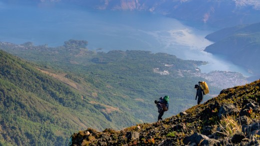
Preparing the bikes for the climb. |?
[/vc_column_text][/vc_column][/vc_row][vc_row full_width=”stretch_row_content_no_spaces” content_placement=”top” css=”.vc_custom_1493323224936{margin-top: 35px !important;margin-bottom: 35px !important;border-top-width: 0px !important;border-bottom-width: 0px !important;background-color: #383838 !important;}”][vc_column parallax=”content-moving” parallax_image=”14904″ offset=”vc_col-lg-offset-2 vc_col-lg-8 vc_col-md-offset-1 vc_col-md-10″][vc_empty_space height=”500px”][/vc_column][/vc_row][vc_row full_width=”stretch_row_content_no_spaces” content_placement=”top” css=”.vc_custom_1493323224936{margin-top: 35px !important;margin-bottom: 35px !important;border-top-width: 0px !important;border-bottom-width: 0px !important;background-color: #383838 !important;}”][vc_column css=”.vc_custom_1493314771844{margin-top: 0px !important;border-top-width: 0px !important;padding-top: 0px !important;background-color: #f9f9f9 !important;}” offset=”vc_col-lg-offset-2 vc_col-lg-8 vc_col-md-offset-1 vc_col-md-10 vc_col-xs-12″][vc_single_image image=”13718″ img_size=”full” onclick=”custom_link” img_link_target=”_blank” css=”.vc_custom_1522878735490{padding-top: 5px !important;padding-right: 5px !important;padding-bottom: 5px !important;padding-left: 5px !important;}” link=”https://www.picsporadic.com/items/BIGMTN-180220-010-G85″][vc_column_text css=”.vc_custom_1522901797231{padding-left: 10px !important;}”]
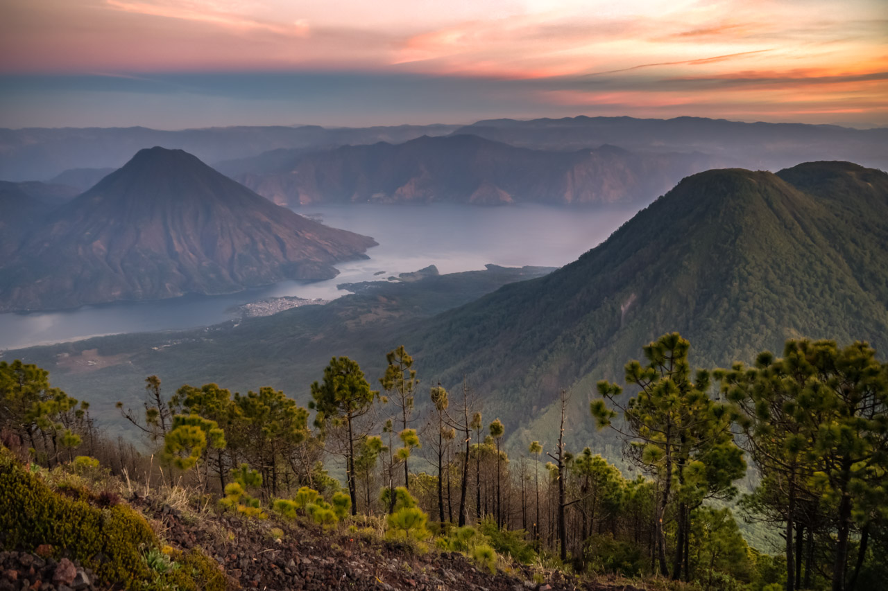
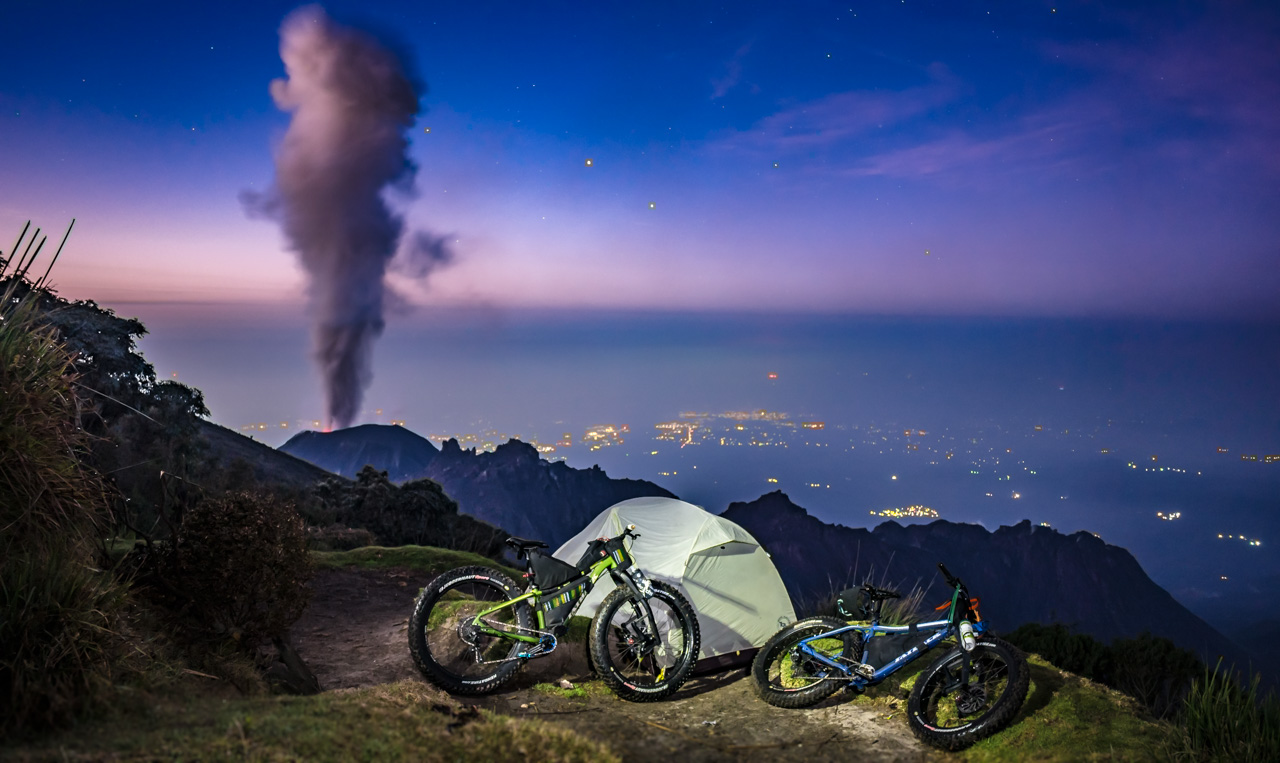
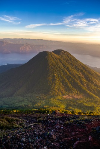
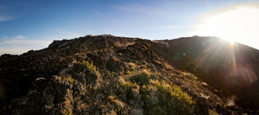
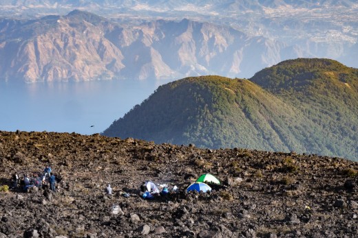
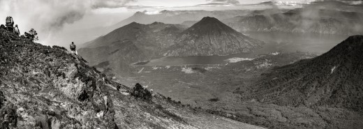
The twin summits of Acatenango are a captivating site as seen from the Antigua valley. The volcano rises 2500 vertical meters like a wall. |?
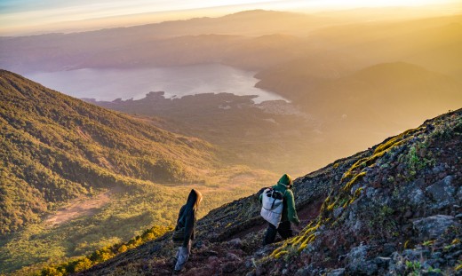
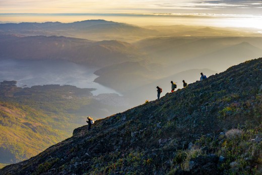
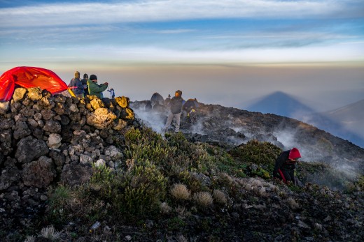
[/vc_column_text][/vc_column][/vc_row][vc_row full_width=”stretch_row_content_no_spaces” equal_height=”yes” content_placement=”top” css=”.vc_custom_1522809113998{margin-top: 0px !important;margin-bottom: 0px !important;border-top-width: 0px !important;border-bottom-width: 0px !important;background-color: #383838 !important;}”][vc_column width=”1/2″ css=”.vc_custom_1522809077799{margin-top: 0px !important;border-top-width: 0px !important;padding-top: 0px !important;background-color: #232323 !important;}” offset=”vc_col-lg-offset-2 vc_col-lg-4 vc_col-md-offset-1 vc_col-md-5 vc_col-xs-12″][vc_custom_heading text=”Volcán Acatenango (3976m)” font_container=”tag:h1|font_size:30px|text_align:left|color:%23ffffff|line_height:30px” google_fonts=”font_family:Alfa%20Slab%20One%3Aregular|font_style:400%20regular%3A400%3Anormal” el_class=”white” css=”.vc_custom_1522809278378{padding-top: 20px !important;padding-left: 20px !important;}”][vc_custom_heading text=”Camping at the top of Guatemala” font_container=”tag:h2|font_size:20|text_align:left|color:%23e8e8e8|line_height:20px” google_fonts=”font_family:Advent%20Pro%3A100%2C200%2C300%2Cregular%2C500%2C600%2C700|font_style:500%20bold%20regular%3A500%3Anormal” el_class=”white” css=”.vc_custom_1522817015447{padding-left: 20px !important;}”][vc_column_text el_class=”white” css=”.vc_custom_1522962436147{padding-top: 20px !important;padding-right: 20px !important;padding-left: 20px !important;}”]One of the most active volcanoes in the world, Fuego erupts quite regularly – but not always. The last time I was up here at night was for Volcanarchy. I remember staying up through the night trying to catch a photo with lava and the stars – I came back empty handed. On this trip with Big Mountain, the mood of the mountain was quite different – to the point where loud eruptions made it hard to sleep with smoke and lava and landslides crashing through the night. Camping next to this force of nature was truly a planetary experience.[/vc_column_text][vc_custom_heading text=”Descent” font_container=”tag:h2|font_size:20|text_align:left|color:%23e8e8e8|line_height:20px” google_fonts=”font_family:Advent%20Pro%3A100%2C200%2C300%2Cregular%2C500%2C600%2C700|font_style:500%20bold%20regular%3A500%3Anormal” el_class=”white” css=”.vc_custom_1522820834029{padding-left: 20px !important;}”][vc_column_text css_animation=”left-to-right” el_class=”white” css=”.vc_custom_1522962589679{padding-right: 20px !important;padding-bottom: 20px !important;padding-left: 20px !important;}”]We awoke before sunrise – a loud boom from Volcán de Fuego rousing us from our tents like groundhogs popping up our heads to get a peak at the action. Lava and catapulting rock set off landslides tumbling onto the ravines below. The porters got the fire lit in the dawn light as we prepared breakfast. Today would be the largest day of the trip, starting at our camp on the volcano and finishing in the forests of Tecpán about 70km away.
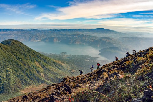
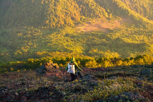
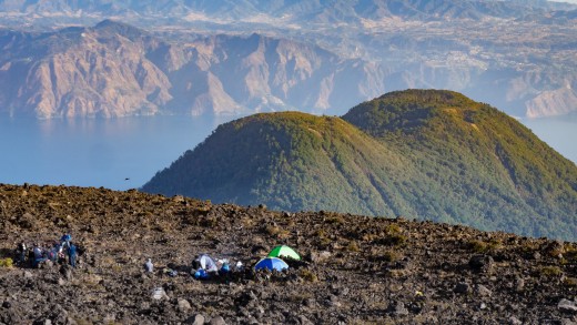
We rolled out of camp and began the 2,000m descent. Traversing above the tree line before cutting down the ash-filled slopes of the volcano. Down and down – with views of the Volcán de Agua and the Antigua valley below. At this speed, the forest becomes a blur of changing micro-climates, transitioning from alpine pines to thick cloud forest, vines, tropical vegetation and eventually finishing in a plantation of peach trees and coffee.
Grinning and still catching our breath we load up the shuttle for the next stage…[/vc_column_text][/vc_column][vc_column parallax=”content-moving” parallax_image=”13783″ width=”1/2″ offset=”vc_col-lg-4 vc_col-md-5″ css=”.vc_custom_1522821043643{border-top-width: 10px !important;border-right-width: 10px !important;border-bottom-width: 10px !important;border-left-width: 10px !important;background-image: url(https://www.picsporadic.com/wp-content/uploads/2018/03/BIGMTN-180221-005-G85.jpg?id=13783) !important;background-position: center !important;background-repeat: no-repeat !important;background-size: cover !important;}”][vc_column_text css=”.vc_custom_1522828466715{padding-right: 20px !important;padding-left: 20px !important;}”]
? The power of Volcán de Fuego |? Purchase
[/vc_column_text][vc_empty_space height=”500px”][/vc_column][vc_column offset=”vc_col-lg-offset-2 vc_col-lg-8 vc_col-xs-12″ css=”.vc_custom_1522810073407{padding: 5px !important;background-color: #232323 !important;}”][jig_vc][justified_image_grid thumbs_spacing=10 row_height=200 height_deviation=100 title_field=caption caption=off mobile_caption=off caption_opacity=1 caption_bg_color=rgba(0,0,0,0.0) caption_text_color=grey caption_align=center lightbox=attachment margin=3 last_row=hide aspect_ratio=1/1 rml_id=172 rml_lightbox_groups=no][/jig_vc][/vc_column][vc_column offset=”vc_col-lg-offset-2 vc_col-lg-8 vc_col-md-offset-1 vc_col-md-10 vc_col-xs-12″ css=”.vc_custom_1522810119501{background-color: #141414 !important;}”][vc_single_image image=”13779″ img_size=”full” onclick=”custom_link” img_link_target=”_blank” css=”.vc_custom_1522799440314{padding-top: 5px !important;padding-right: 5px !important;padding-bottom: 5px !important;padding-left: 5px !important;}” link=”https://www.picsporadic.com/items/BIGMTN-180220-339-G85″][vc_column_text css=”.vc_custom_1522901760541{padding-left: 10px !important;}”]Watching stars and trading stories around the campfire. It took 11 porters to carry our supplies to highcamp and many spent the night with us on the volcano. | ?[/vc_column_text][/vc_column][vc_column parallax=”content-moving-fade” parallax_image=”14793″ parallax_speed_bg=”1.2″ offset=”vc_col-lg-offset-2 vc_col-lg-8 vc_col-md-offset-1 vc_col-md-10″][vc_empty_space height=”440px”][vc_column_text css=”.vc_custom_1522901697115{padding-right: 10px !important;padding-left: 10px !important;background-color: rgba(2,2,2,0.44) !important;*background-color: rgb(2,2,2) !important;}”]
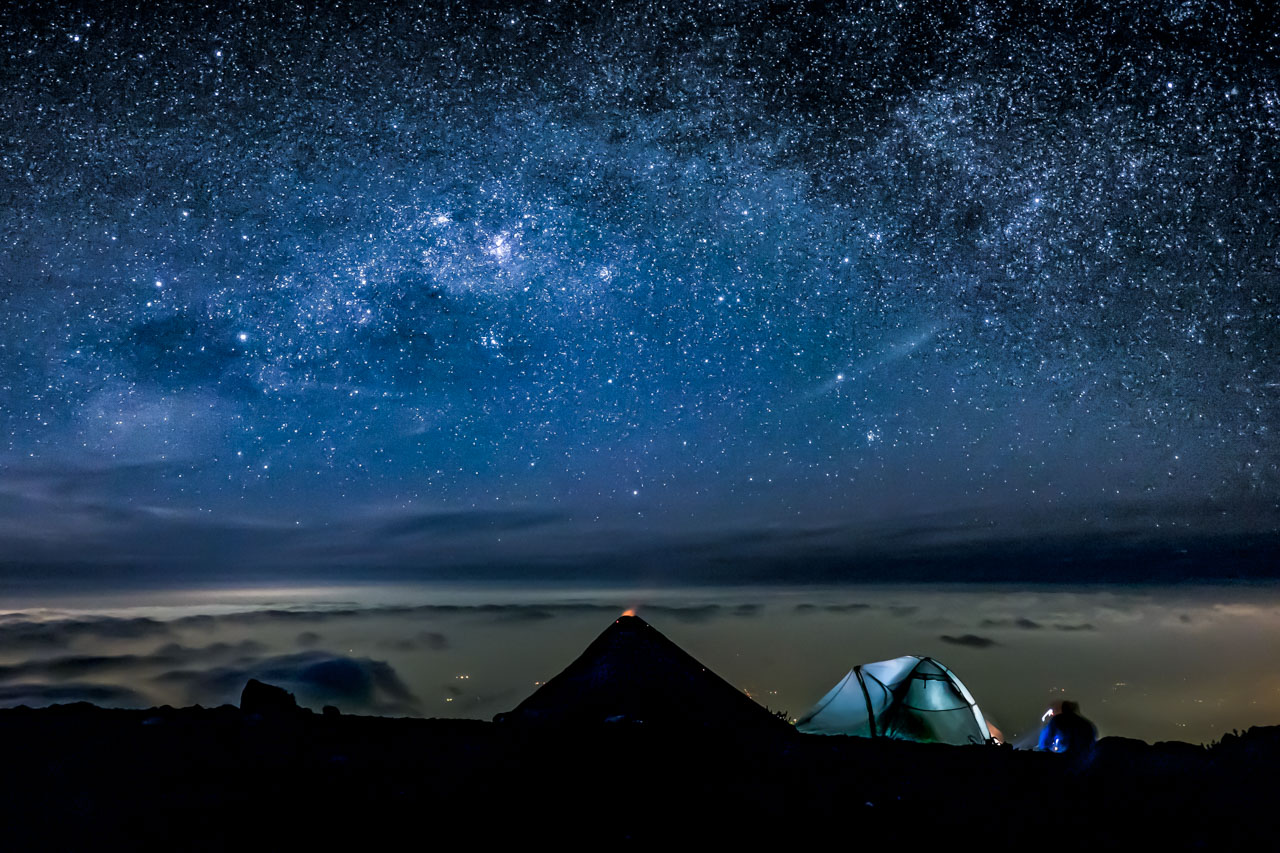
Milky Way over Volcán de Agua and the lights of Alotenango – 3am |? Purchase
[/vc_column_text][/vc_column][/vc_row][vc_row full_width=”stretch_row_content_no_spaces” content_placement=”top” css=”.vc_custom_1493323224936{margin-top: 35px !important;margin-bottom: 35px !important;border-top-width: 0px !important;border-bottom-width: 0px !important;background-color: #383838 !important;}”][vc_column css=”.vc_custom_1493314771844{margin-top: 0px !important;border-top-width: 0px !important;padding-top: 0px !important;background-color: #f9f9f9 !important;}” offset=”vc_col-lg-offset-2 vc_col-lg-8 vc_col-md-offset-1 vc_col-md-10 vc_col-xs-12″][vc_single_image image=”13846″ img_size=”full” onclick=”custom_link” img_link_target=”_blank” css=”.vc_custom_1522879023022{padding-top: 5px !important;padding-right: 5px !important;padding-bottom: 5px !important;padding-left: 5px !important;}” link=”https://www.picsporadic.com/items/BIGMTN-180221-220-G85″][vc_column_text css=”.vc_custom_1522903684530{padding-left: 10px !important;}”]
Wily Quino riding off in the morning from camp on Volcán Acatenango |?
[/vc_column_text][/vc_column][/vc_row][vc_row full_width=”stretch_row_content_no_spaces” equal_height=”yes” content_placement=”top” css=”.vc_custom_1493316115647{margin-top: 0px !important;margin-bottom: 0px !important;border-top-width: 0px !important;border-bottom-width: 0px !important;background-color: #383838 !important;}”][vc_column width=”1/2″ offset=”vc_col-lg-offset-2 vc_col-lg-4 vc_col-md-offset-1 vc_col-md-5 vc_col-sm-offset-0 vc_col-xs-12″ css=”.vc_custom_1522821790120{background-color: #f4f4f4 !important;}”][vc_single_image image=”13918″ img_size=”full” onclick=”custom_link” img_link_target=”_blank” link=”https://www.picsporadic.com/items/BIGMTN-180221-839-G85″ css=”.vc_custom_1522903094574{padding: 5px !important;}”][vc_column_text css=”.vc_custom_1522903133503{padding-left: 10px !important;}”]
Penny Cameron riding among the thistle. |?
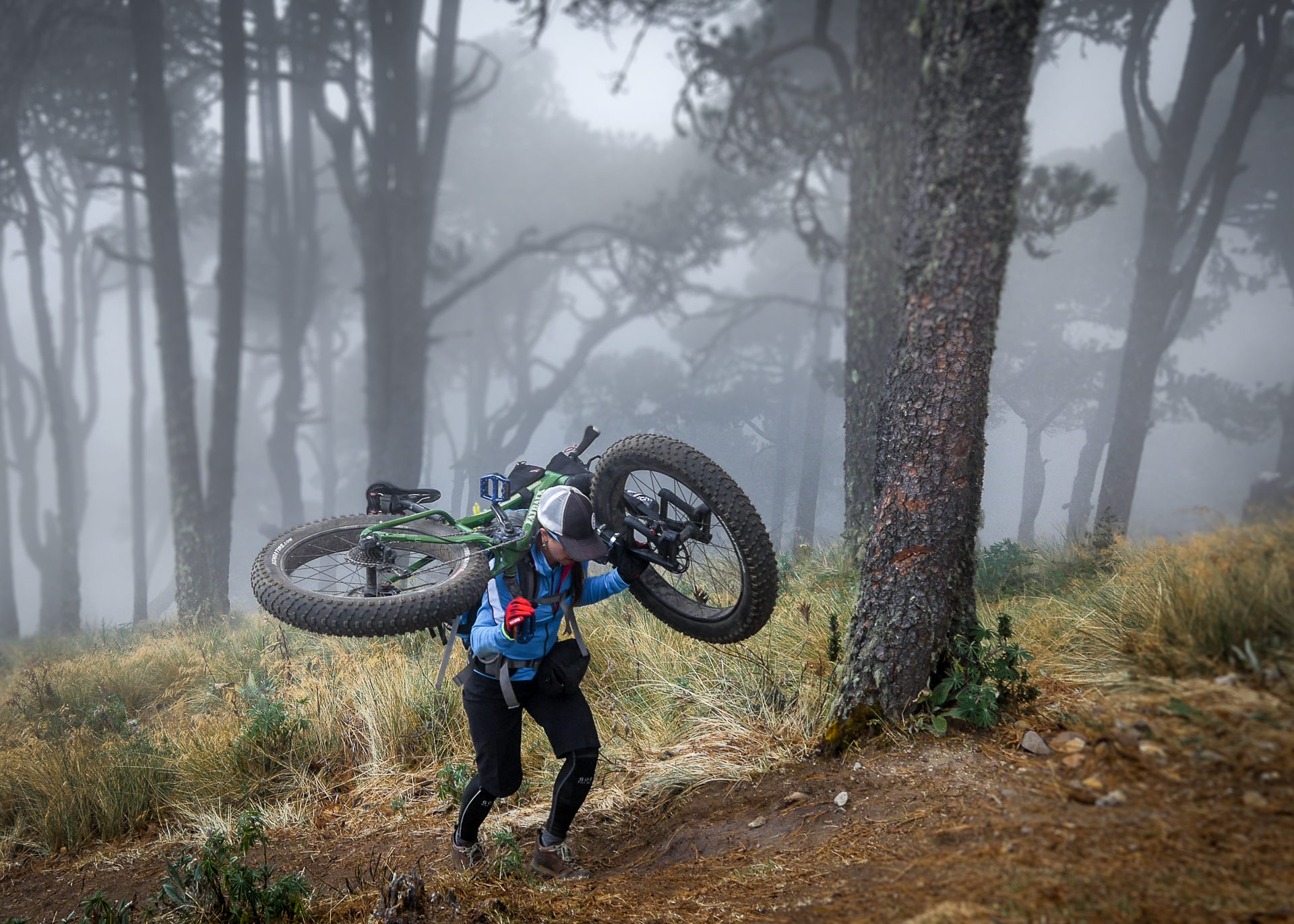
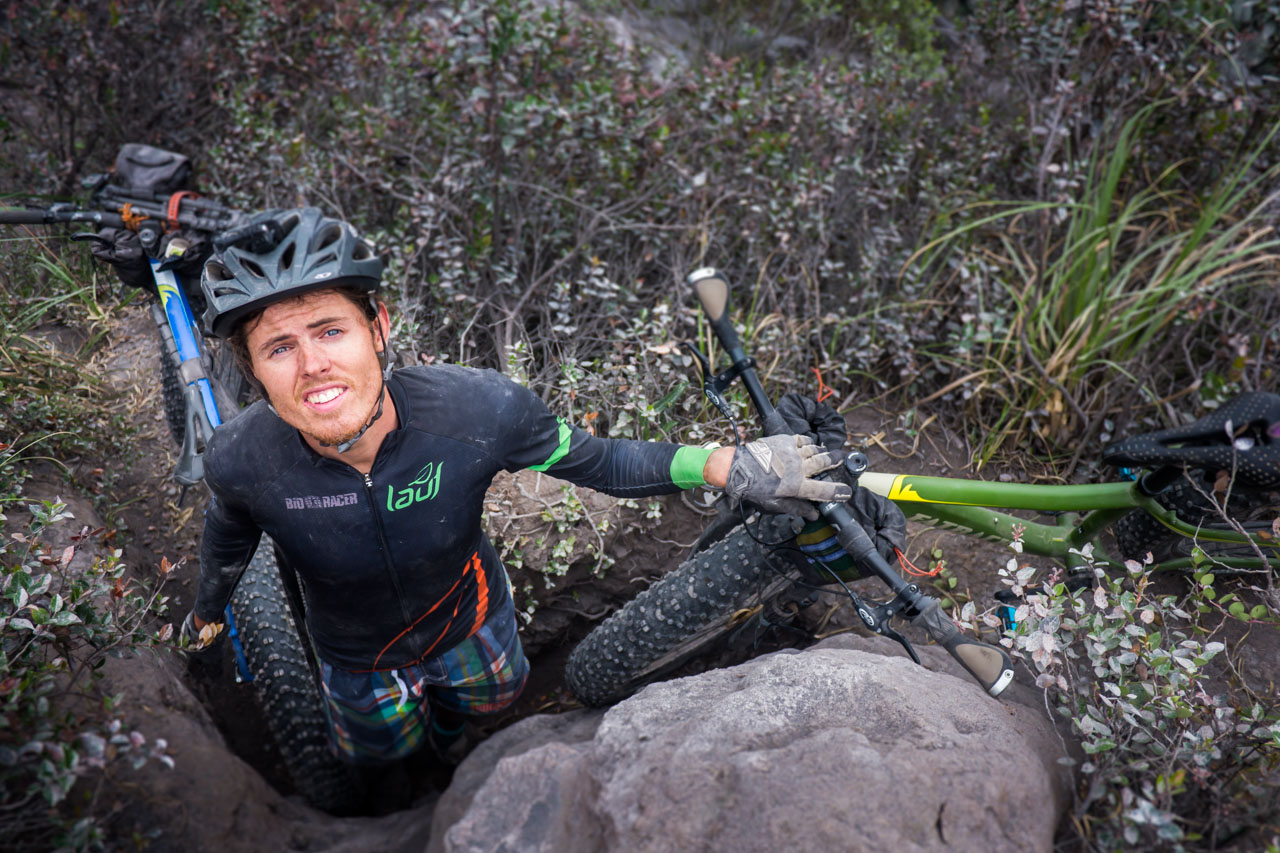
[/vc_column_text][/vc_column][vc_column width=”1/2″ css=”.vc_custom_1493409675120{padding-top: 20px !important;padding-right: 20px !important;padding-bottom: 20px !important;padding-left: 20px !important;background-color: #f4f4f4 !important;}” offset=”vc_col-lg-4 vc_col-md-5″][vc_custom_heading text=”High Alpine Traverse” font_container=”tag:h2|font_size:20|text_align:left|color:%233f3f3f|line_height:20px” google_fonts=”font_family:Advent%20Pro%3A100%2C200%2C300%2Cregular%2C500%2C600%2C700|font_style:500%20bold%20regular%3A500%3Anormal” el_class=”white”][vc_column_text]A few weeks prior I had been out scouting the route of the tour. Rural Guatemala is a spiderweb of footpaths, canyons and ravines. In effort to bypass the panamerican highway we followed an ancient footpath along a high alpine ridge. Unfortunately, the trail was overgrown and required a substantial hike-a-bike / bushwhack to make the connection.
We returned with machetes to clear the trail: it took 5 men the better part of a day to clear back the dense forest. But the result was a trail few people knew about. I was eager not only to share this spot but also to ride it for the first time (truly ride it) by bike.
The trail is an aesthetic line that connects two mountain with views in all directions from an alpine meadow. This is Adventure MTB at it’s finest.[/vc_column_text][vc_column_text]A few weeks prior I had been out scouting the route of the tour. Rural Guatemala is a spiderweb of footpaths, canyons and ravines. In effort to bypass the panamerican highway we followed an ancient footpath along a high alpine ridge. Unfortunately, the trail was overgrown and required a substantial hike-a-bike / bushwhack to make the connection.
We returned with machetes to clear the trail: it took 5 men the better part of a day to clear back the dense forest. But the result was a trail few people knew about. I was eager not only to share this spot but also to ride it for the first time (truly ride it) by bike.
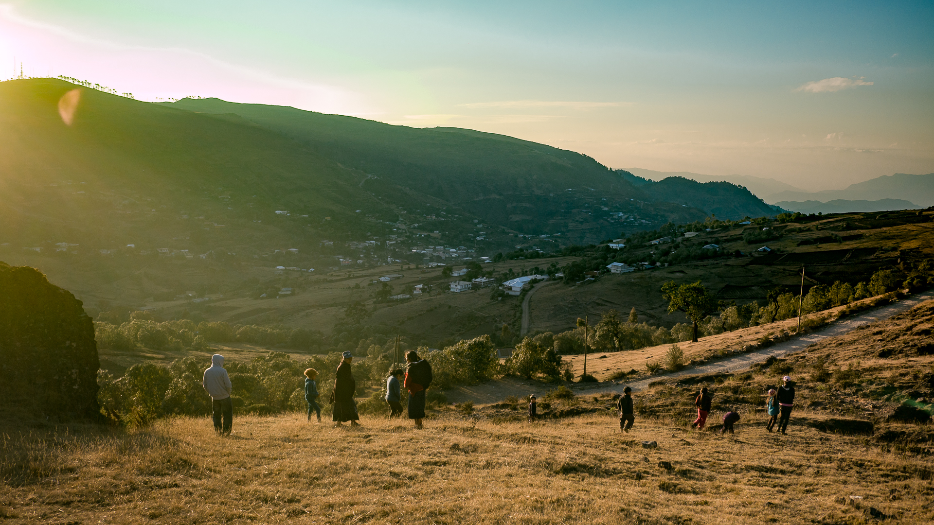
The trail is an aesthetic line that connects two mountain with views in all directions from an alpine meadow. This is Adventure MTB at it’s finest.[/vc_column_text][/vc_column][vc_column offset=”vc_col-lg-offset-2 vc_col-lg-8 vc_col-md-offset-1 vc_col-md-10″ css=”.vc_custom_1522821719213{padding-right: 5px !important;padding-left: 5px !important;background-color: #f4f4f4 !important;}”][jig_vc][justified_image_grid thumbs_spacing=10 row_height=150 height_deviation=200 title_field=caption caption=off mobile_caption=off caption_opacity=1 caption_bg_color=rgba(0,0,0,0.0) caption_text_color=grey caption_align=center lightbox=attachment margin=5 limit=4 last_row=hide rml_id=173 rml_lightbox_groups=no][/jig_vc][/vc_column][/vc_row][vc_row full_width=”stretch_row_content_no_spaces” equal_height=”yes” content_placement=”top” css=”.vc_custom_1522874901132{margin-top: 40px !important;margin-bottom: 0px !important;border-top-width: 0px !important;border-bottom-width: 0px !important;background-color: #383838 !important;}”][vc_column parallax=”content-moving” parallax_image=”13959″ parallax_speed_bg=”1.2″ offset=”vc_col-lg-offset-2 vc_col-lg-8 vc_col-md-offset-1 vc_col-md-10″][vc_empty_space height=”500px”][/vc_column][vc_column width=”5/12″ offset=”vc_col-lg-offset-2 vc_col-lg-4 vc_col-md-offset-1 vc_col-md-5 vc_col-sm-offset-0 vc_col-xs-12″ css=”.vc_custom_1493313751677{padding-top: 20px !important;padding-right: 20px !important;padding-bottom: 20px !important;padding-left: 20px !important;background-color: #f9f9f9 !important;}”][vc_custom_heading text=”Kingdom of the Kaqchikel Maya” font_container=”tag:h2|font_size:20|text_align:left|color:%233f3f3f|line_height:20px” google_fonts=”font_family:Advent%20Pro%3A100%2C200%2C300%2Cregular%2C500%2C600%2C700|font_style:500%20bold%20regular%3A500%3Anormal” el_class=”white”][vc_column_text]Located at 2,100m in a forested region above Lake Atitlán, Tecpán is home to Iximché, a former Mayan metropolis from the post-classic period (300AD). The kingdom was violently overthrown by the Spanish in the 1500s. Conquest proved difficult because of the city’s strategic location atop a cliff band in the center of a canyon.
Later on, although briefly, the Spanish established their first capital in the region. It is also said that Guatemala gets its name from the Mexican Náhuatl translators the Spanish had with them, who interpreted the Maya K’iche’ word for “between the trees” as Quauhtemallan or “place of many trees”.[/vc_column_text][/vc_column][vc_column width=”7/12″ css=”.vc_custom_1522902758411{padding-top: 20px !important;padding-right: 0px !important;padding-bottom: 20px !important;padding-left: 0px !important;background-color: #f9f9f9 !important;}” offset=”vc_col-lg-4 vc_col-md-5″][vc_single_image image=”13971″ img_size=”large” onclick=”custom_link” img_link_target=”_blank” link=”https://www.picsporadic.com/items/BIGMTN-180222-149-G85″ css=”.vc_custom_1522902767682{padding-left: 10px !important;}”][vc_column_text css=”.vc_custom_1522901649187{padding-left: 10px !important;}”]
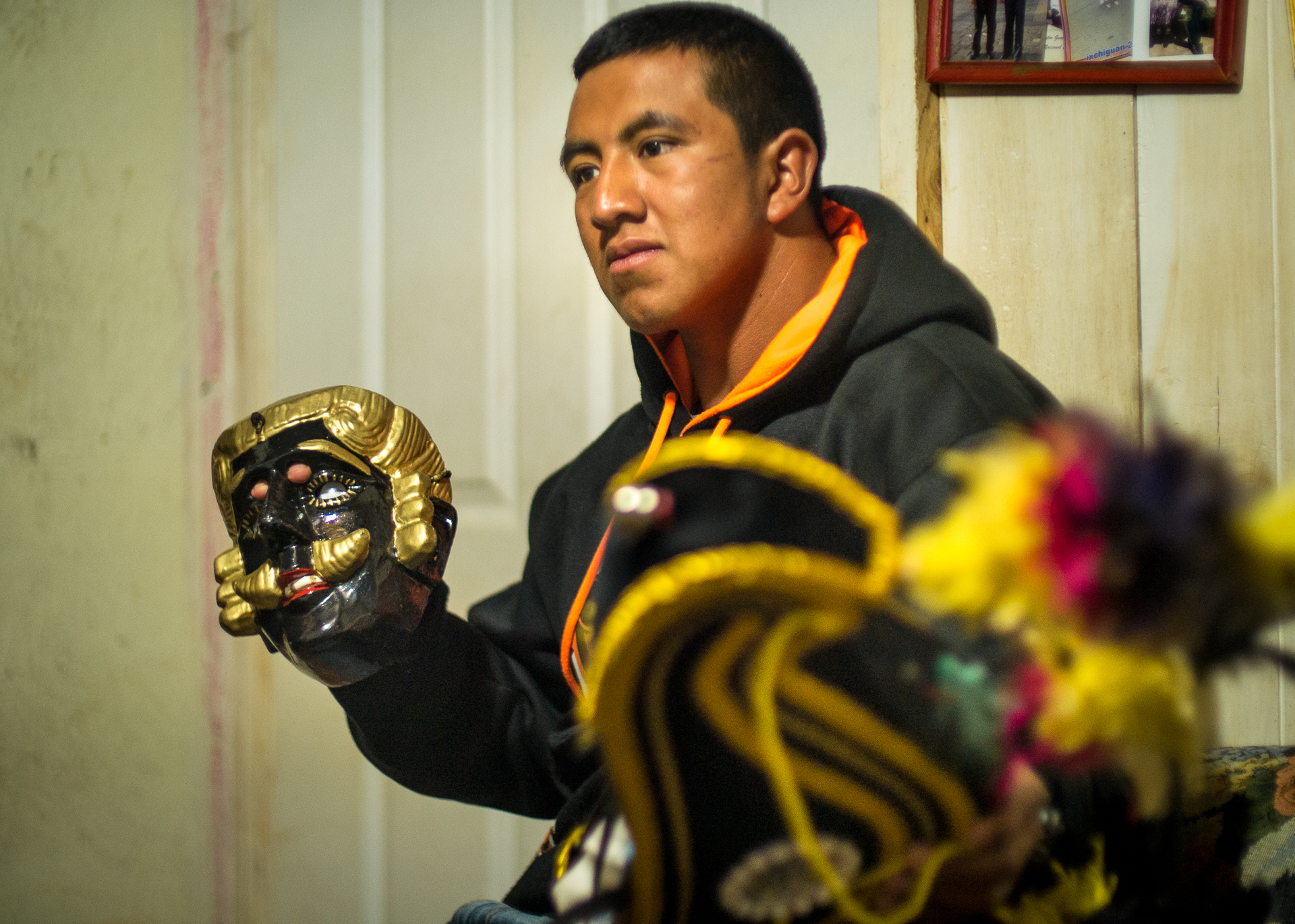
A Mayan priest performs a fire ceremony at Ixcimché | ?
[/vc_column_text][/vc_column][vc_column parallax=”content-moving-fade” parallax_image=”14907″ parallax_speed_bg=”1.2″ offset=”vc_col-lg-offset-2 vc_col-lg-8 vc_col-md-offset-1 vc_col-md-10″ css=”.vc_custom_1522897531758{margin-bottom: 0px !important;border-bottom-width: 0px !important;padding-bottom: 0px !important;}”][vc_empty_space height=”500px”][vc_column_text css=”.vc_custom_1522827256485{margin-bottom: 0px !important;border-bottom-width: 0px !important;padding-bottom: 0px !important;background-color: rgba(2,2,2,0.44) !important;*background-color: rgb(2,2,2) !important;}”]
Local guide Alex explains the history of the ruins. ? Purchase
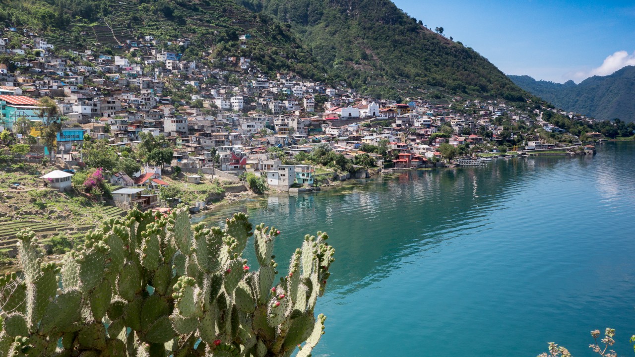
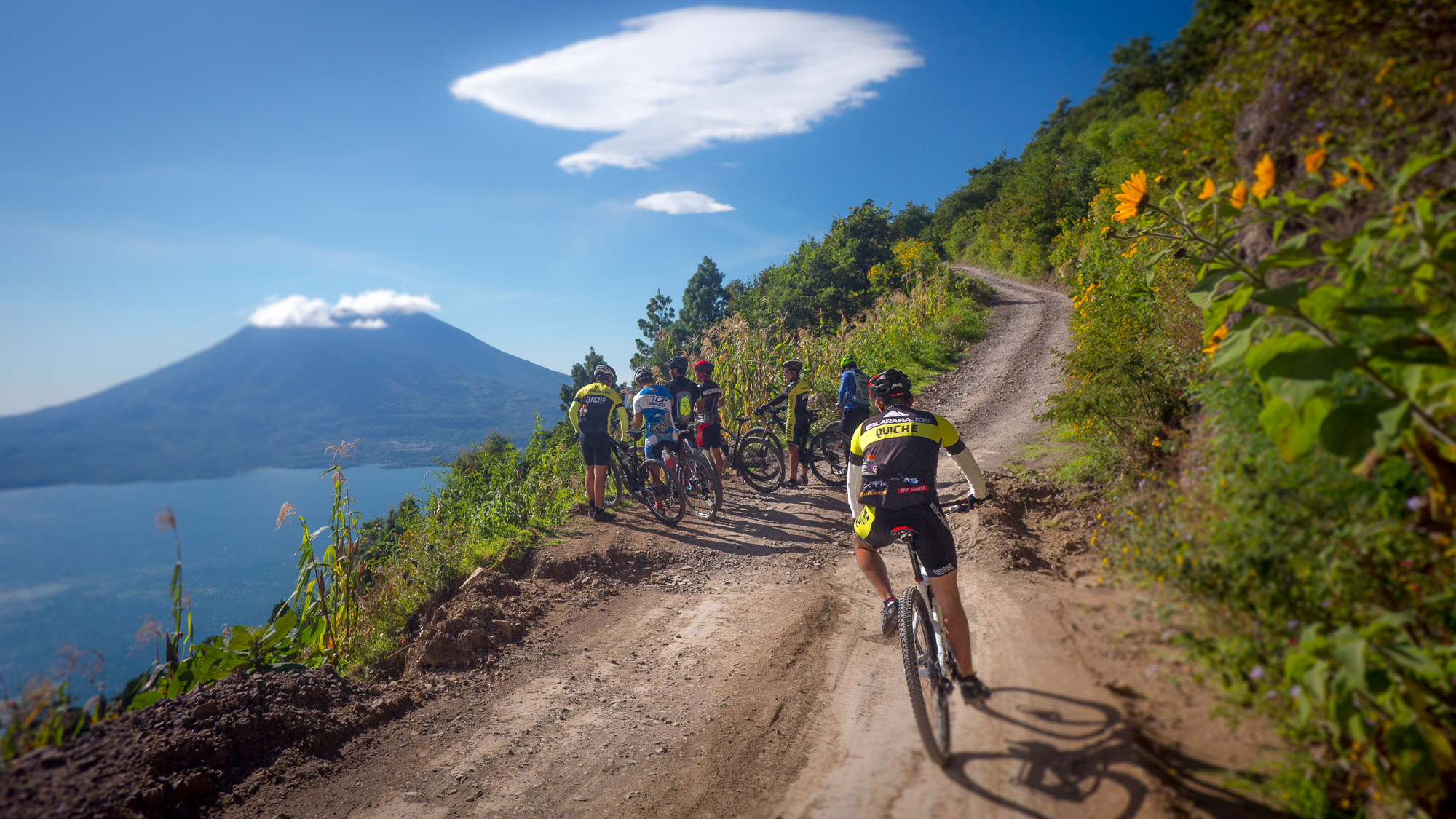
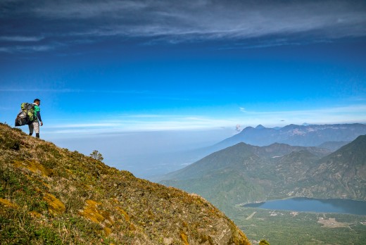
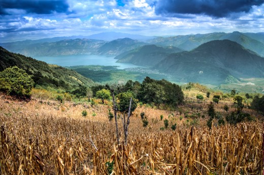
[/vc_column_text][/vc_column][/vc_row][vc_row full_width=”stretch_row_content_no_spaces” equal_height=”yes” content_placement=”top” css=”.vc_custom_1522893193416{margin-top: 30px !important;margin-bottom: 0px !important;border-top-width: 0px !important;border-bottom-width: 0px !important;background-color: #383838 !important;}”][vc_column width=”1/2″ offset=”vc_col-lg-offset-2 vc_col-lg-4 vc_col-md-offset-1 vc_col-md-5 vc_col-sm-offset-0 vc_col-xs-12″ css=”.vc_custom_1493409656577{padding-top: 20px !important;padding-right: 20px !important;padding-bottom: 20px !important;padding-left: 20px !important;background-color: #f4f4f4 !important;}”][vc_custom_heading text=”Lake Atitlán” font_container=”tag:h1|font_size:30px|text_align:left|color:%233f3f3f|line_height:40px” google_fonts=”font_family:Alfa%20Slab%20One%3Aregular|font_style:400%20regular%3A400%3Anormal” el_class=”white”][vc_custom_heading text=”Finishing at a caldera in the sky” font_container=”tag:h2|font_size:20|text_align:left|color:%233f3f3f|line_height:20px” google_fonts=”font_family:Advent%20Pro%3A100%2C200%2C300%2Cregular%2C500%2C600%2C700|font_style:500%20bold%20regular%3A500%3Anormal” el_class=”white”][vc_column_text]The greatest treat of this tour for me was being able to show the Big Mountain group one of my favorite places to ride in Guatemala: Lake Atitlán. The trails here are technical, rocky, and steep, with volcanic views that make it hard to keep your eyes on the handlebars! This supervolcanic crater is steep in all directions with 1,000 to 2,000m downhills – I always find a new challenge when riding the raw trails here.
We shuttled up to the town of San Andrés, home to pine forests and agricultural trails that sweep down through cornfields and onto tight streets. Children scream and wave as we roll through town. We break at a stunning lookout where paragliders launch into thermal drafts, taking off at 2,000m.[/vc_column_text][vc_single_image image=”14003″ img_size=”large” onclick=”custom_link” img_link_target=”_blank” link=”https://www.picsporadic.com/items/BIGMTN-180222-256-G85″][vc_column_text el_class=”white”]We finished our last ride on the legendary Santa Catarina trail: nearly 1,000m of rocky downhill that follows an aqueduct along a cliff above the lake. Technical riding that is demanding to the very end, finishing through the stepped streets of town.[/vc_column_text][/vc_column][vc_column width=”1/2″ css=”.vc_custom_1522826282733{padding-top: 20px !important;padding-right: 20px !important;padding-bottom: 20px !important;padding-left: 20px !important;background: #f4f4f4 url(https://www.picsporadic.com/wp-content/uploads/2018/03/BIGMTN-180222-645-G85.jpg?id=14092) !important;background-position: center !important;background-repeat: no-repeat !important;background-size: cover !important;}” offset=”vc_col-lg-4 vc_col-md-5″][vc_empty_space height=”400px”][/vc_column][/vc_row][vc_row full_width=”stretch_row_content_no_spaces” content_placement=”top” css=”.vc_custom_1493323224936{margin-top: 35px !important;margin-bottom: 35px !important;border-top-width: 0px !important;border-bottom-width: 0px !important;background-color: #383838 !important;}”][vc_column css=”.vc_custom_1493314771844{margin-top: 0px !important;border-top-width: 0px !important;padding-top: 0px !important;background-color: #f9f9f9 !important;}” offset=”vc_col-lg-offset-2 vc_col-lg-8 vc_col-md-offset-1 vc_col-md-10 vc_col-xs-12″][vc_single_image image=”13977″ img_size=”full” onclick=”custom_link” img_link_target=”_blank” css=”.vc_custom_1522890500937{padding-top: 5px !important;padding-right: 5px !important;padding-bottom: 5px !important;padding-left: 5px !important;}” link=”https://www.picsporadic.com/items/BIGMTN-180222-164-G85″][vc_column_text css=”.vc_custom_1522901621298{padding-right: 10px !important;padding-left: 10px !important;}”]First views of Lake Atitán. Rider Cathy Jewett descends dusty singletrack above San Andres This is mtbguatemala. | ?
[/vc_column_text][/vc_column][/vc_row][vc_row full_width=”stretch_row_content_no_spaces” content_placement=”top” css=”.vc_custom_1493409190465{margin-top: 35px !important;margin-bottom: 35px !important;border-top-width: 0px !important;border-bottom-width: 0px !important;background-color: #383838 !important;}”][vc_column css=”.vc_custom_1493409688645{margin-top: 0px !important;border-top-width: 0px !important;padding-top: 0px !important;background-color: #f4f4f4 !important;}” offset=”vc_col-lg-offset-2 vc_col-lg-8 vc_col-md-offset-1 vc_col-md-10 vc_col-xs-12″][vc_single_image image=”14058″ img_size=”full” onclick=”custom_link” img_link_target=”_blank” css=”.vc_custom_1521333601870{padding-top: 5px !important;padding-right: 5px !important;padding-bottom: 5px !important;padding-left: 5px !important;}” link=”https://www.picsporadic.com/items/BIGMTN-180222-501-G85″][vc_column_text css=”.vc_custom_1522901607887{padding-right: 10px !important;padding-left: 10px !important;}”]
Candace Shadley riding the Urban downhill in the tight streets of Santa Catarina Palopó |?
[/vc_column_text][/vc_column][/vc_row][vc_row full_width=”stretch_row_content_no_spaces” equal_height=”yes” content_placement=”top” css=”.vc_custom_1493316115647{margin-top: 0px !important;margin-bottom: 0px !important;border-top-width: 0px !important;border-bottom-width: 0px !important;background-color: #383838 !important;}”][vc_column offset=”vc_col-lg-offset-2 vc_col-lg-8 vc_col-md-offset-1 vc_col-md-10 vc_col-xs-12″ css=”.vc_custom_1522894091802{background-color: #f9f9f9 !important;}”][vc_single_image image=”14078″ img_size=”full” onclick=”custom_link” img_link_target=”_blank” css=”.vc_custom_1522891350388{padding-top: 5px !important;padding-right: 5px !important;padding-bottom: 5px !important;padding-left: 5px !important;}” link=”https://www.picsporadic.com/items/BIGMTN-180222-608-G85″][/vc_column][vc_column width=”1/2″ offset=”vc_col-lg-offset-2 vc_col-lg-4 vc_col-md-offset-1 vc_col-md-5 vc_col-sm-offset-0 vc_col-xs-12″ css=”.vc_custom_1493409656577{padding-top: 20px !important;padding-right: 20px !important;padding-bottom: 20px !important;padding-left: 20px !important;background-color: #f4f4f4 !important;}”][vc_custom_heading text=”We made it” font_container=”tag:h2|font_size:20|text_align:left|color:%233f3f3f|line_height:20px” google_fonts=”font_family:Advent%20Pro%3A100%2C200%2C300%2Cregular%2C500%2C600%2C700|font_style:500%20bold%20regular%3A500%3Anormal” el_class=”white”][vc_column_text]On the shore of the lake, the late-day sun glistens on the water. We are on the last part of the ride, following a path along the beach. Brightly colored stands and vendors line the sidewalks in Panajachel, their calls and whistles merge into a collage of sound as we ride by.
One of the most enjoyable aspects of riding in Latin America is passing through markets like this. The stimulation and stolen glances of the people, the men playing cards, the children laughing as you roll past. “This place is incredible”, I hear someone mutter.[/vc_column_text][/vc_column][vc_column width=”1/2″ css=”.vc_custom_1522902797867{padding-top: 5px !important;padding-right: 5px !important;padding-left: 10px !important;background-color: #f4f4f4 !important;}” offset=”vc_col-lg-4 vc_col-md-5″][vc_column_text css=”.vc_custom_1553129892494{margin-top: 40px !important;margin-right: 10px !important;}”]It’s another beautiful day in Guatemala and our 6-day ride has come to an end. Tomorrow, we’ll spend the day resting at Casa Del Mundo, a cliff-side hotel with nothing to do but watch the light change, fading through its spectrum at the end of the day.
In a little while, our guests will go back to skiing in the northern hemisphere with nothing but memories and sun-tans to show for their time spent here in Guatemala. I can only hope that they come back some day and we can ride a little more. We have just scratched the surface of the riding here and there is still much more to discover.
-Brendan James
[/vc_column_text][/vc_column][/vc_row][vc_row full_width=”stretch_row_content_no_spaces” content_placement=”top” css=”.vc_custom_1493229127906{margin-top: 0px !important;margin-bottom: 0px !important;border-top-width: 0px !important;border-bottom-width: 0px !important;background-color: #383838 !important;}”][vc_column css=”.vc_custom_1493409747415{margin-top: 0px !important;margin-bottom: 35px !important;border-top-width: 0px !important;padding-top: 0px !important;background-color: #f4f4f4 !important;}” offset=”vc_col-lg-offset-2 vc_col-lg-8 vc_col-md-offset-1 vc_col-md-10 vc_col-xs-12″][vc_single_image image=”12572″ img_size=”full” onclick=”custom_link” img_link_target=”_blank” css=”.vc_custom_1522822392518{padding-top: 5px !important;padding-right: 5px !important;padding-bottom: 5px !important;padding-left: 5px !important;}” link=”https://www.picsporadic.com/items/Guatemala-171220-099-G85-HDR”][vc_column_text css=”.vc_custom_1522903294711{padding-right: 10px !important;padding-left: 10px !important;}”]
Sunsets here linger for hours at Lake Atitlán. At 2,000m the horizon glows long after the sun sinks past the volcanoes. |?
[/vc_column_text][/vc_column][/vc_row][vc_row full_width=”stretch_row_content_no_spaces” css=”.vc_custom_1493266731151{margin-right: 0px !important;margin-bottom: 0px !important;margin-left: 0px !important;border-bottom-width: 0px !important;border-left-width: 0px !important;background-color: #383838 !important;}”][vc_column offset=”vc_col-lg-offset-2 vc_col-lg-8 vc_col-md-offset-1 vc_col-md-10 vc_col-sm-offset-0 vc_col-xs-12″ css=”.vc_custom_1493409798261{padding-top: 20px !important;padding-right: 20px !important;padding-bottom: 20px !important;padding-left: 20px !important;background-color: #232323 !important;}”][vc_text_separator title=”Gallery” title_align=”separator_align_left” el_class=”gallerytext” css=”.vc_custom_1493266781501{margin-right: 20px !important;}”][/vc_column][vc_column offset=”vc_col-lg-offset-2 vc_col-lg-8 vc_col-md-offset-1 vc_col-md-10 vc_col-xs-12″ css=”.vc_custom_1493266954426{padding-right: 5px !important;padding-left: 5px !important;background-color: #232323 !important;}”][jig_vc][justified_image_grid row_height=230 height_deviation=100 mobile_row_height=120 caption=off mobile_caption=off orderby=rand max_rows=12 last_row=hide load_more=click initially_load=12 recent_posts=yes recents_filter_tax=collection recents_filter_term=big-mountain-2017 recents_post_type=sell_media_item][/jig_vc][vc_column_text css=”.vc_custom_1522896337874{margin-top: 20px !important;padding-bottom: 20px !important;}”]
[/vc_column_text][vc_separator color=”white” border_width=”2″][/vc_column][/vc_row][vc_row full_width=”stretch_row_content” equal_height=”yes” content_placement=”middle” css=”.vc_custom_1493268745972{margin-top: 0px !important;margin-bottom: 0px !important;border-top-width: 0px !important;border-bottom-width: 4px !important;padding-bottom: 4px !important;background-color: #383838 !important;border-top-color: #777777 !important;border-bottom-color: #777777 !important;}”][vc_column width=”3/4″ offset=”vc_col-lg-offset-2 vc_col-lg-5 vc_col-md-offset-1 vc_col-md-6 vc_col-xs-12″ css=”.vc_custom_1522868110217{margin-bottom: 0px !important;border-bottom-width: 0px !important;padding-bottom: 0px !important;background-color: #232323 !important;}”][vc_column_text]Published: [date] by PICSPORADIC [/vc_column_text][/vc_column][vc_column width=”1/12″ offset=”vc_col-md-2 vc_col-xs-6″ css=”.vc_custom_1522898035693{margin-bottom: 0px !important;border-bottom-width: 0px !important;padding-bottom: 0px !important;background-color: #232323 !important;}”][vc_facebook type=”button_count” css=”.vc_custom_1490816047681{margin-top: 4px !important;}”][/vc_column][vc_column width=”1/3″ offset=”vc_col-lg-1 vc_col-md-2 vc_col-xs-6″ css=”.vc_custom_1522898046828{margin-bottom: 0px !important;border-bottom-width: 0px !important;padding-bottom: 0px !important;background-color: #232323 !important;}”][vc_googleplus annotation=”none” css=”.vc_custom_1490816144508{margin-top: 2px !important;}”][/vc_column][/vc_row][vc_row full_width=”stretch_row_content_no_spaces” css=”.vc_custom_1493266731151{margin-right: 0px !important;margin-bottom: 0px !important;margin-left: 0px !important;border-bottom-width: 0px !important;border-left-width: 0px !important;background-color: #383838 !important;}”][vc_column offset=”vc_col-lg-offset-2 vc_col-lg-8 vc_col-md-offset-1 vc_col-md-10 vc_col-xs-12″ css=”.vc_custom_1522897446650{margin-bottom: 0px !important;border-bottom-width: 0px !important;padding-top: 40px !important;padding-bottom: 40px !important;background-color: #efefef !important;}”][vc_row_inner equal_height=”yes” content_placement=”middle” css=”.vc_custom_1522897400184{border-top-width: 2px !important;border-right-width: 2px !important;border-bottom-width: 2px !important;border-left-width: 2px !important;padding-top: 20px !important;padding-right: 20px !important;padding-bottom: 20px !important;padding-left: 20px !important;border-left-style: none !important;border-right-style: none !important;border-top-style: none !important;border-bottom-style: none !important;}”][vc_column_inner width=”1/4″ offset=”vc_col-lg-offset-2 vc_col-lg-3 vc_col-md-offset-1 vc_col-md-3 vc_col-sm-offset-2 vc_col-xs-offset-3 vc_col-xs-6″ css=”.vc_custom_1553129921397{padding-top: 20px !important;}”][vc_single_image image=”14941″ img_size=”large” alignment=”center” style=”vc_box_circle_2″ css=”.vc_custom_1522898070361{margin-bottom: 20px !important;}”][/vc_column_inner][vc_column_inner width=”5/12″ offset=”vc_col-lg-5 vc_col-md-5 vc_col-xs-12″ css=”.vc_custom_1522897768129{padding-left: 20px !important;}”][vc_custom_heading text=”Like what you read?” font_container=”tag:h2|font_size:24|text_align:left|color:%233f3f3f|line_height:20px” google_fonts=”font_family:Exo%3A100%2C100italic%2C200%2C200italic%2C300%2C300italic%2Cregular%2Citalic%2C500%2C500italic%2C600%2C600italic%2C700%2C700italic%2C800%2C800italic%2C900%2C900italic|font_style:700%20bold%20regular%3A700%3Anormal” el_class=”white”][vc_column_text]The best way you can support the work I do is through purchasing photos and prints on this site.
I love seeing my photos in print!
All photos here are available in high resolution – they can be downloaded and printed at up to 48in on the longest side. Prices start at $2.99
Check out the store for more: www.picsporadic.com/digital[/vc_column_text][/vc_column_inner][/vc_row_inner][/vc_column][/vc_row]


 El sendero de las Avutardas


 [/vc_column_text][/vc_column][/vc_row][vc_row css=”.vc_custom_1472242229346{margin-bottom: 0px !important;border-bottom-width: 0px !important;padding-bottom: 0px !important;background-color: #383838 !important;}”][vc_column offset=”vc_col-lg-offset-1 vc_col-lg-10 vc_col-md-offset-1 vc_col-md-10 vc_col-xs-12″ css=”.vc_custom_1490865093175{margin-top: 0px !important;margin-bottom: 0px !important;border-top-width: 0px !important;border-bottom-width: 0px !important;padding-top: 0px !important;padding-bottom: 0px !important;}”][vc_custom_heading text=”Meet the Team:” font_container=”tag:h2|font_size:50px|text_align:left|color:%23ffffff|line_height:60px” google_fonts=”font_family:Exo%3A100%2C100italic%2C200%2C200italic%2C300%2C300italic%2Cregular%2Citalic%2C500%2C500italic%2C600%2C600italic%2C700%2C700italic%2C800%2C800italic%2C900%2C900italic|font_style:600%20bold%20regular%3A600%3Anormal”][/vc_column][/vc_row][vc_row equal_height=”yes” content_placement=”top” css=”.vc_custom_1490856258776{margin-top: 0px !important;margin-bottom: 0px !important;border-top-width: 0px !important;border-bottom-width: 0px !important;padding-top: 0px !important;padding-bottom: 0px !important;background-color: #383838 !important;}”][vc_column width=”5/12″ offset=”vc_col-lg-offset-2 vc_col-lg-3 vc_col-md-offset-1 vc_col-md-4 vc_col-xs-12″ css=”.vc_custom_1490857506616{margin-top: 0px !important;margin-bottom: 0px !important;border-top-width: 0px !important;border-bottom-width: 0px !important;padding-top: 0px !important;padding-bottom: 0px !important;background-color: #232323 !important;}”][vc_single_image image=”15845″ img_size=”full” alignment=”center” style=”vc_box_circle_2″ css=”.vc_custom_1553237349433{margin-top: 50px !important;margin-right: 20px !important;margin-bottom: 20px !important;margin-left: 20px !important;}”][/vc_column][vc_column width=”7/12″ offset=”vc_col-lg-offset-0 vc_col-lg-5 vc_col-md-offset-0 vc_col-md-6″ css=”.vc_custom_1490856199671{padding-bottom: 10px !important;background-color: #232323 !important;}”][vc_custom_heading text=”Manuel Aristondo” font_container=”tag:h2|font_size:35|text_align:left|color:%23ffffff”][vc_custom_heading text=”Owner, Perubybike” font_container=”tag:h2|font_size:18|text_align:left|color:%23fbd63a|line_height:20px” google_fonts=”font_family:Exo%3A100%2C100italic%2C200%2C200italic%2C300%2C300italic%2Cregular%2Citalic%2C500%2C500italic%2C600%2C600italic%2C700%2C700italic%2C800%2C800italic%2C900%2C900italic|font_style:500%20bold%20italic%3A500%3Aitalic” css=”.vc_custom_1490855642325{margin-bottom: 0px !important;border-bottom-width: 0px !important;padding-bottom: 0px !important;}”][vc_column_text css=”.vc_custom_1490857613268{margin-top: 20px !important;margin-bottom: 20px !important;padding-top: 10px !important;padding-right: 10px !important;padding-bottom: 10px !important;padding-left: 10px !important;background-color: #e2e2e2 !important;border-radius: 5px !important;}” el_class=”smalltext”]Manuel is a lifelong lover of adventure sports. He a degree in Tourism Management from the University of San Martin de Porres in Lima, Peru. He has run 12 marathons and trekked in many of the country’s national parks.